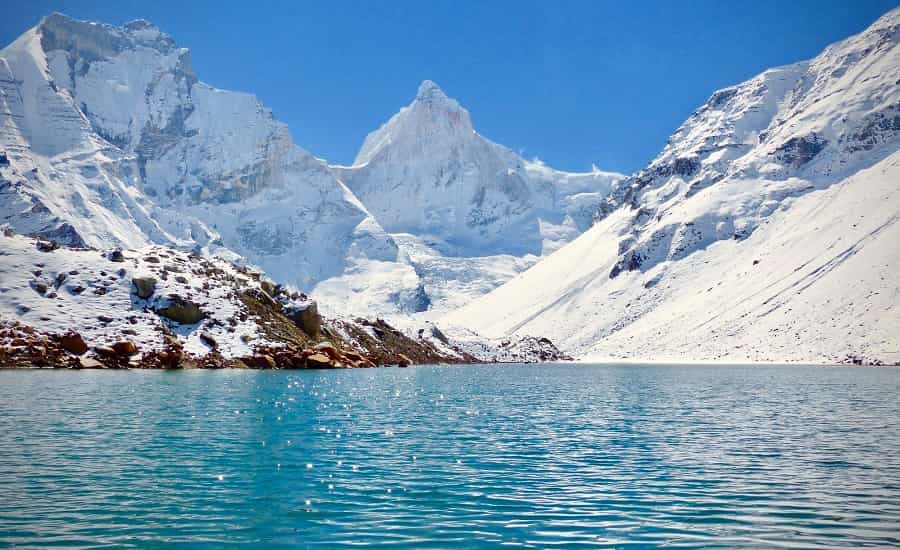
ABOUT THE KEDARTAL (SHIVA’S LAKE):
The destination of Kedartal is also called “Shiva’s Lake”. The glacial lake is situated at an altitude of 4780 m in the Garhwal Himalayas of Uttarakhand. The lake has inflows from Thalay Sagar (6,904 m), Meru ( 6,672 m) and Bhrigupanth ( 6,772 m) and other peaks encompassing the region and is a source of ” Kedar Ganga” which according to Hindu Mythology is considered as Lord’s Shiva’s contribution to Bhagirathi. The place is situated 17 km from Gangotri. Starting from here Kedartal Trek route goes through Bhoj Kharak which is 8 km away. This is a steep and rocky climb along the narrow Kedar Ganga Gorge. The route from here is 4 km to the next camping site of Kedar kharak and 5 km down to Kedartal. The place is filled with the beauty of alpine and the Himalayan forest, bubbling streams and glaciers, but it is a little dangerous one because of falling rocks, high altitude, and segments of sharp and narrow ascent.
KEDARTAL TREK:
The Kedartal trek starts from Gangotri which is at an altitude of 3,415 m. It is one of the most revered Hindu pilgrimage spots, and one of small pilgrimage site in the Chota Char Dham Pilgrimage Circuit. Goddess Gangotri is the presiding deity of the shrine. Here, the Kedar Tal Trek takes a diversion to Bhoj Kharak at 3,989 m. From here it is a tough and arduous walk to Kedartal. At the backdrop, one can see the massive Himalayas that surround the lakes from all the sides. The surrounding environs provide a heavenly experience to the travelers. This Kedartal trek is considered to be moderate which is more suitable for trekkers having prior experience.
KEDARTAL TREK HIGHLIGHTS:
- Region: Garhwal, Uttarakhand
- Starting Point: Uttarkashi
- Ending Point: Uttarkashi
- Duration: 6 days and 5 nights
- Ideal Time: Mid May-Mid
- Level: A challenging and hard 6-day long trek requires perfect mountaineering expertise.
- Total Distance: 60 Km
- Maximum elevation: 16,000 Ft.
- Weather: Summers are pleasant and cool winds blowing thru the Himalayas. Winters are very cold with heavy snowfall.
- Communication: Emergency communication becomes difficult after Sankri as connectivity will be In case trekkers are with a group walkie-talkies will be there to communicate with the base camp.
- ATM Point: Uttarkashi is the last point where travelers can find ATM’s.
KEY FACTS ABOUT KEDARTAL TREK:
- Also called as Shiva’s lake it is one of the most splendid and spectacular glacial lakes in Uttarakhand. It can be called a trek of “Serenity with Variety“.
- The surrounding peaks are snow-capped mountains of Thalay Sagar, Bhrigupanth, Meru, Jogin. It is a sheer beauty to watch melting snow in summer from these peaks!.
- On a clear day, travelers can watch the enchanting view of the reflection of Thalay Sagar peak on the ‘Tal’ lake bed.
- Trekkers usually need about 3 days to acclimatize to the weather conditions considering the steep ascent of the trek.
- The thick foliage, forests and flora, and fauna besides posing tough conditions teaches the trekkers the need to be patient and skillful to surmount the challenges on the way.
- Proper mental and physical fitness are
- Camping overnight after every thousand meters is recommended.
- An experienced trekking guide is a must, for providing valuable insights and guidance during the whole Kedartal trek.
ITINERARY
DAY- 1 DEHRADUN – UTTARKASHI – GANGOTRI: 10 HOURS – DRIVE 258 KMS
Take a shared cab from Rispana Pul in Dehradun. – Travel to Uttarkashi will take about 6 Hours through the Mussoorie Road. The journey provides splendid views of the Tehri Dam and Chilyani Saur. After a short halt at Uttarkashi, travelers continue to travel to Gangotri via Harsil which takes about 4 Hours. Starting at 6 AM one can reach Uttarkashi around 12 Noon. After a shortbread, travelers can again pool cabs to reach Gangotri by evening 5 PM. Interested travelers can perform an Aarti at the temple and get the permission to enter the Gangotri National Park. Travelers can preferably acclimatize by going on a hike to Surya Kund – Thereafter, relax and stay at Gangotri for the night
DAY- 2 GANGOTRI- BHOJ KHARAK (12,400 FT) – 8 HOURS – 8 KMS
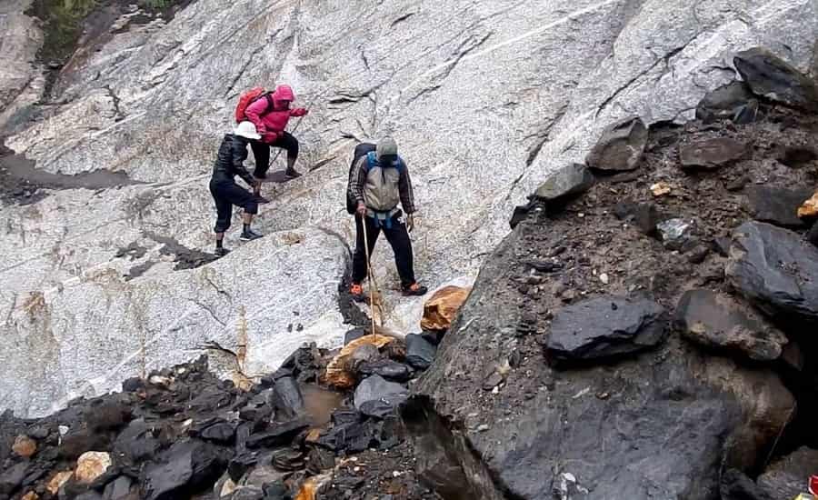
The day usually starts with a visit to the sacred shrine of Goddess Gangotri and glimpses of the local market. Thereafter, cross the bridge of the Bhagirathi River and start the ascent. Walk the steep at a slow pace not to get exhausted quickly. The trail goes through the pine forests and enters the mixed vegetation area filled with Bhoj and Fir trees. Travelers can regale in the scenic beauty of Kedar Ganga, flowing from the hilltop thru the gorge. Travelers can also get a stunning view of the Thalay Sagar peak. Before reaching Bhoj Kharak, the steep and slant rocks have a few steps in between (also called as ‘Spider Wall’). Sometime in early June or late October if the rocks are covered with snow then travelers need great skill to cross this area because an inadvertent slip can drag travelers few hundred feet below. The travelers should reach Bhoj Kharak around afternoon and then proceed to Lower Kedar Kharak for an overnight stay.
DAY- 3 BHOJ KHARAK – KEDAR KHARAK: – 5 HOURS – 5 KMS
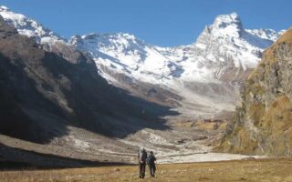
Traversing along the rugged terrains, travelers reach Kedar Kharak. The scenery changes every 30 minutes – Starting with rich flora and fauna filled with Bhojpatra trees and forest bushes one gets to see the tall Manda peaks next. In addition, the Bhrigupanth peaks near Kedar Kharak are sure to mesmerize and hypnotize travelers. Thereafter cross the land sliding zone of Gila Pahar. If this section is bad, alternatively travelers can trek down to Kedar Ganga, cross the river and then hike upstream till Gila Pahar intersection – travelers can hike back to reach Kedar Kharak. As travelers go towards Lower Kedar Kharak (4100 m) a wide valley is seen and the trek finishes at the lush meadows of the Kedar Kharak situated at an elevation of 4280 m. The stretch needs a great amount of physical stamina though the distance is only 5 Km. One gets to see the Kedar Kharak campsites in the Gangotri National Park region. One of the special attractions of the region – ‘Bharal’ ( blue sheep) is found here. The view of the Thalaysagar and the Bhrigupanth in their majestic forms is itself a fantastic dream to witness for travelers.
DAY- 4 KEDAR KHARAK – KEDAR TAL – JOGIN ABC – KEDAR TAL – 5 HOURS – 10 KMS
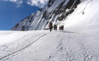
This is a 5 km long trek route to Kedar Tal, that is covered mostly with moraines and glaciers. Trekking in June will make travelers witness only snow before they reach Kedartal. Travelers have to cross the brook with ice cold waters and climb the steep rocky terrain. Follow the cairn marking to ensure that travelers are not lost. After reaching the final spot travelers see the Kedar Bamak Glacier. Here the Mt. Bhrigupanth and Mt. Thalay Sagar merges with the Kedar Bamak Glacier and is a lovely sight. Trekking for an hour more would give stunning views of the spotless Kedar Tal and the high altitude lake. The view of the Thalay Sagar on the Kedar Tal is still more beautiful. Leave Kedartal at noon to explore Jogin advance base camp and trek towards Jogin ABC (4900 m).
DAY- 5 KEDAR TAL – GANGOTRI – 9 HOURS – 17 KMS
Witness the exotic views of the sunrise and then go and enjoy a long and tiring hike back to Gangotri. Travelers should target to reach Bhoj Kharak by 3.00PM so that they can proceed to Gangotri or camp at Bhoj Kharak.
DAY- 6 GANGOTRI – UTTARKASHI – DEHRADUN – 10 HOURS – 258 KMS
Wake up early in the morning to capture the beautiful scenery of the sunrise as this is the final day of the tour and travelers arrive at Dehradun from Gangotri.
INCLUSIONS
Accommodation:
Gangotri is the final point where travelers can find comfortable accommodation when traveling to Kedartal Trek. Trekkers must carry their own camping tents for accommodation.
Meal:
In this trek meals are provided from snacks, the trekkers get a variety of foods ( tasty and healthy) that range from Indian, Chinese and also some Western foods with plenty of fruits and vegetables on the platter.
Activities:
The various activities include the following:
- Mountaineering
- Photography
- Trekking
- Cycling
- Rafting
Other Inclusions:
The Kedartal Trek has some other inclusions like:
- All important permits, environmental charges, and forest camping.
- All essential trekking equipment- sleeping bags, tents, inner mattress, dining and toilet tents.
- Porter for food items, cook, and a mule kitchen and various equipment.
- A certified mountaineering guide throughout the Kedar Tal trek.
- Services of a well-experienced trek leader.
TRANSPORTATION:
By Train- Haridwar is the closest railway station from the base of the camp. It is located at a distance of 248 km from Uttarkashi with a travel time of around 9 Hours. A bus or a cab can be hired to reach Kedartal which is 55 Kms away with a travel time of around 2 Hours.
By Air- Jolly Grant Airport in Dehradun is the closest airport which located around 150 km from Uttarkashi with a travel time of around 5 Hours. A bus or a cab can be hired to reach Kedartal which is 55 Kms away with a travel time of around 2 Hours.
By Road– Dehradun is well connected by road with all Indian cities. Kedartal is around 205 Kms away with a travel time of around 7 Hours.
HOW TO REACH
One can reach Kedartal by two routes:
- Delhi – Haridwar – Rishikesh – Uttarkashi – Gangotri – Bhoj Kharak – Kedar and Kharak –
- Kedar Tal – Bhoj Kharak – Gangotri – Rishikesh – Haridwar – Delhi.
- There are a lot of a/c Volvo buses available to Kedartal it gives an enjoyable ride to the base camp at Mt. Thalay Sagar and Mt. Bhrigupant. Taxis are available in plenty from Rishikesh, Haridwar, Dehradun. From Dehradun, the journey time from Rishikesh is about 12 hours and can be reached by SUV’s, other vehicles, and privately operated jeeps. Some important road distances are Yamunotri (224 km), Dharasu (129 km), Tehri (172 km) and Mussoorie (247 km).
DOCUMENTS
- Health insurance documents- Health insurance cards and copies of claim forms
- Proof of yellow fever vaccination- If in case the trip needs travelers to take the completed International Certificate of Vaccination or Prophylaxis card or medical waiver.
- Copies of all prescriptions- Be sure to get copies of all prescriptions that have generic drug names. Also bring prescriptions for eyeglasses/ contacts, and other medical supplies.
- Photo Identity ID Card – Aadhaar, PAN, Driving Licence, Voter Id (Better to carry copies for submission to any agencies)
- Contact details:
- For handling any emergencies, it is suggested to carry cards having contact numbers, email
WEATHER CONDITIONS
Summer is the right time to visit Kedartal (May – June) when the climatic conditions are pleasant and wholesome and the temperature is 5*C- 15*C. In the winter the temperature is -3*C – -5*C. and completely covered with snow. In summer, the Himalayas are clearly visible, and the cool breeze gives more beauty and charisma to the vacation.
This is yet another trek which provides travelers a lifetime experience to witness nature at its best and be among them free from all normal routines. This is an exotic destination and a paradise on the earth for trekkers to relax, enjoy, refresh and rejuvenate themselves.