Odisha — historically known as Orissa — is one of India’s most water-rich states. The rivers and lakes in Odisha shape the state’s geography, agriculture, ecology, and culture. From Chilika Lake, Asia’s largest brackish water lagoon and India’s first Ramsar site, to the Mahanadi River that powers the world’s longest earthen dam at Hirakud, and from the sacred Baitarani to the Rushikulya where millions of Olive Ridley turtles nest — Odisha’s water bodies are extraordinary in their scale and ecological importance.
This guide covers all major rivers, lakes, reservoirs, waterfalls, and hot springs of Odisha with verified 2026 data, Ramsar designations, wildlife census figures, and practical travel information.
Odisha Rivers and Lakes — Key Facts at a Glance
| Fact | Answer |
|---|---|
| Largest lake in Odisha | Chilika Lake (Asia’s largest brackish lagoon; 900–1,165 sq km) |
| Largest freshwater lake | Ansupa Lake (~231 ha; Ramsar site since 2021) |
| Longest river | Mahanadi (858 km; largest drainage basin in Odisha) |
| World’s longest earthen dam | Hirakud Dam (25.8 km; across Mahanadi near Sambalpur) |
| Number of Ramsar sites | 3 — Chilika (1981), Ansupa (2021), Hirakud Reservoir (2021) |
| India’s first Ramsar site | Chilika Lake (designated 1 October 1981) |
| Major rivers | Mahanadi, Brahmani, Baitarani, Rushikulya, Subarnarekha, Budhabalanga, Vamsadhara |
| Hirakud Dam inaugurated | 13 January 1957 (PM Nehru); construction completed 1953 |
| Famous for Olive Ridley turtles | Rushikulya river mouth, Ganjam (~7 lakh turtles in 2025 — record) |
| Irrawaddy dolphins in Chilika | 159 (Feb 2026 census) — world’s highest single-lagoon population |
Key Entity Relationships
| Entity | Related To | Relationship |
|---|---|---|
| Chilika Lake | Ramsar Convention | India’s first Ramsar site (1981); restored from Montreux Record 2002 |
| Hirakud Dam | Mahanadi River | Built across Mahanadi; world’s longest earthen dam; Ramsar site (2021) |
| Ansupa Lake | Mahanadi River | Oxbow lake formed from abandoned Mahanadi meander; Ramsar site (2021) |
| Brahmani River | Dhamra Estuary | Forms shared delta with Baitarani; drains to Bay of Bengal at Dhamra |
| Baitarani River | Gonasika Hills | Originates in Keonjhar; sacred Guptaganga underground source |
| Rushikulya River | Olive Ridley Turtles | Major mass nesting (arribada) site; ~7 lakh turtles in Feb 2025 |
| Satkosia Gorge | Mahanadi River | 22 km gorge cut by Mahanadi through Eastern Ghats; Tiger Reserve |
1. Chilika Lake — Asia’s Largest Brackish Water Lagoon

| Detail | Information |
|---|---|
| Location | Puri, Khurda and Ganjam districts, Odisha |
| Type | Brackish water coastal lagoon (estuarine) |
| Area | 900 sq km (summer) to 1,165 sq km (monsoon) |
| Dimensions | ~64.5 km long; width 5–18 km; connected to Bay of Bengal via 32 km channel |
| Ramsar Status | India’s first Ramsar site — 1 October 1981 |
| Irrawaddy Dolphins | 159 (Feb 2026 official census) — world’s highest single-lagoon population |
| Migratory Birds | Over 225 species of migratory and resident birds recorded; peak count Nov–Feb |
| Fish Species | 317+ species; supports ~200,000 fishermen families |
| Best Time | November to February (peak migratory birds; Irrawaddy dolphins most visible) |
Chilika Lake is the largest brackish water lagoon in Asia and the second largest coastal lagoon in the world. Fed by 52 rivers and rivulets, it spans three districts of Odisha and supports an extraordinary range of biodiversity. Chilika hosts the world’s highest single-lagoon population of Irrawaddy dolphins — 159 individuals recorded in the February 2026 annual census by the Odisha Forest Department. The count has been stable at 159 for two consecutive years (2025 and 2026), indicating a healthy and stable population.
Chilika was designated India’s first Ramsar Wetland on 1 October 1981. After ecological degradation from siltation, it was added to the Ramsar Montreux Record (Threatened list) in 1993 and successfully removed in 2002 after restoration by the Chilika Development Authority — the first Ramsar site in Asia to achieve this. The Chilika Development Authority received the Ramsar Wetland Conservation Award in 2002.
Key Attractions at Chilika Lake
- Satapada Island — Best location for Irrawaddy dolphin boat trips; 159 dolphins confirmed in Feb 2026 census.
- Nalabana Bird Sanctuary — A 16 sq km island declared bird sanctuary in 1987. Peak count: over 900,000 birds in a single January census.
- Kalijai Island Temple — Sacred temple on an island inside Chilika; accessible by boat; busy during Makar Sankranti.
- Rambha Bay — Popular boating and sunset-viewing area on the southern end of the lake.
- Migratory Birds — Over 225 species from Russia, Mongolia, Central Asia arrive November–February. Actual annual counts vary; peak winter counts exceed 1 million birds.
Must Read on: Popular Hindu Temples to Visit in Odisha
2. Mahanadi River — Odisha’s Lifeline
| Detail | Information |
|---|---|
| Total Length | 858 km (494 km in Odisha; 357 km in Chhattisgarh) |
| States | Chhattisgarh and Odisha only |
| Origin | Sihawa Hills, Dhamtari district, Chhattisgarh (~422 m elevation) |
| Drains into | Bay of Bengal near Paradip and False Point, Odisha |
| Drainage Basin | ~141,600 sq km (largest in Odisha) |
| Left Tributaries | Seonath, Hasdeo, Mand, Ib |
| Right Tributaries | Ong, Tel, Jonk |
| Key Landmarks | Satkosia Gorge (Tiger Reserve), Hirakud Dam, Cuttack city |
The Mahanadi is Odisha’s longest and largest river — the sixth largest in India by water potential among peninsular rivers. It flows through Chhattisgarh and Odisha only, originating in the Sihawa hills of Chhattisgarh and draining into the Bay of Bengal via a broad delta near Paradip. The river does not flow through Madhya Pradesh or Jharkhand.
The Mahanadi historically caused devastating delta floods. Hirakud Dam significantly controlled this while generating hydroelectric power and supporting irrigation across western Odisha. Six small streams between the Mahanadi and Rushikulya also drain directly into Chilika Lake.
Satkosia Gorge
A 22 km canyon where the Mahanadi cuts through the Eastern Ghats in Angul district. It is a Tiger Reserve home to mugger crocodiles, gharials, Indian pythons, and diverse birdlife — one of Odisha’s premier ecotourism destinations.
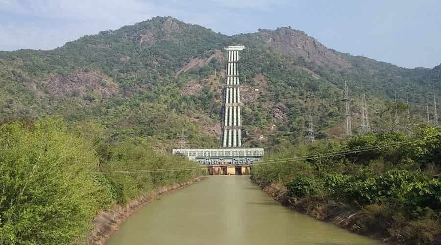
3. Hirakud Dam — World’s Longest Earthen Dam
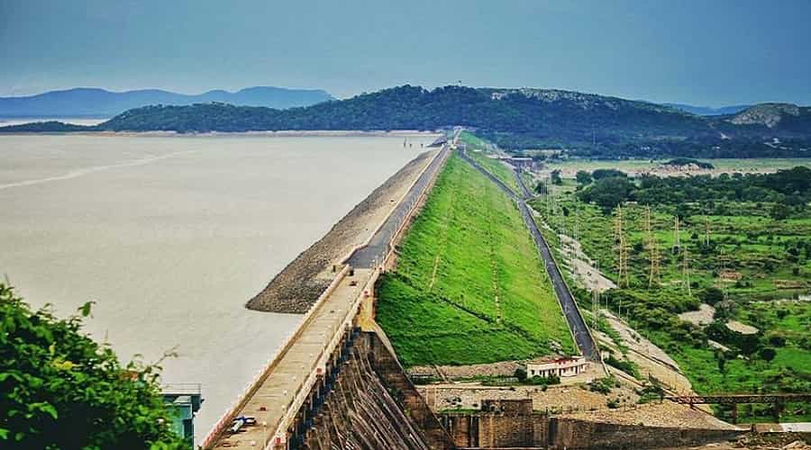
| Detail | Information |
|---|---|
| Location | ~15 km north of Sambalpur, Odisha |
| River | Mahanadi |
| Total Length (with dykes) | 25.8 km — world’s longest earthen dam |
| Main Dam Length | 4.8 km (composite: concrete, earth and masonry) |
| Height | 60.96 m (200 ft) |
| Reservoir Length | 55 km |
| Foundation Stone | 15 March 1946 (Sir Hawthorne Lewis) |
| First Concrete Laid | 12 April 1948 (PM Jawaharlal Nehru) |
| Construction Completed | 1953 |
| Formally Inaugurated | 13 January 1957 (PM Jawaharlal Nehru) |
| Power Generation | Started 1956; full capacity by 1966; Installed: 347.5 MW |
| Ramsar Status | Ramsar Wetland since 12 October 2021 |
Hirakud Dam, built across the Mahanadi approximately 15 km north of Sambalpur, is the world’s longest earthen dam at 25.8 km. It was one of independent India’s first major multipurpose river projects. Construction began with the foundation stone laid on 15 March 1946, first concrete poured by PM Nehru on 12 April 1948, completed in 1953, and inaugurated 13 January 1957. The Hirakud Reservoir was declared a Ramsar Wetland in October 2021.
Cattle Island
A submerged hilltop that became an island after the dam’s construction. Wild cattle have roamed here for generations. Reachable by boat from the dam area; access is subject to seasonal conditions and forest department permissions.
Debrigarh Wildlife Sanctuary
Adjacent to Hirakud Reservoir; home to leopards, sloth bears, spotted deer, and many migratory birds. An excellent companion visit to Hirakud Dam.
4. Ansupa Lake — Odisha’s Largest Freshwater Lake
| Detail | Information |
|---|---|
| Location | Banki, Cuttack district, Odisha |
| Distance from Cuttack | ~40–46 km west (verified: Wikipedia, Incredible India, Odisha Tourism) |
| Type | Freshwater oxbow lake (abandoned Mahanadi meander) |
| Surface Area | ~231 ha (570 acres) — varies seasonally |
| Ramsar Status | Ramsar Wetland since 12 October 2021 |
| Biodiversity | 50+ migratory/resident bird species; 33 fish species; 10+ reptile species |
| Best Time | October to February |
| Entry | Entry charges may vary; verify with Odisha Tourism before visiting |
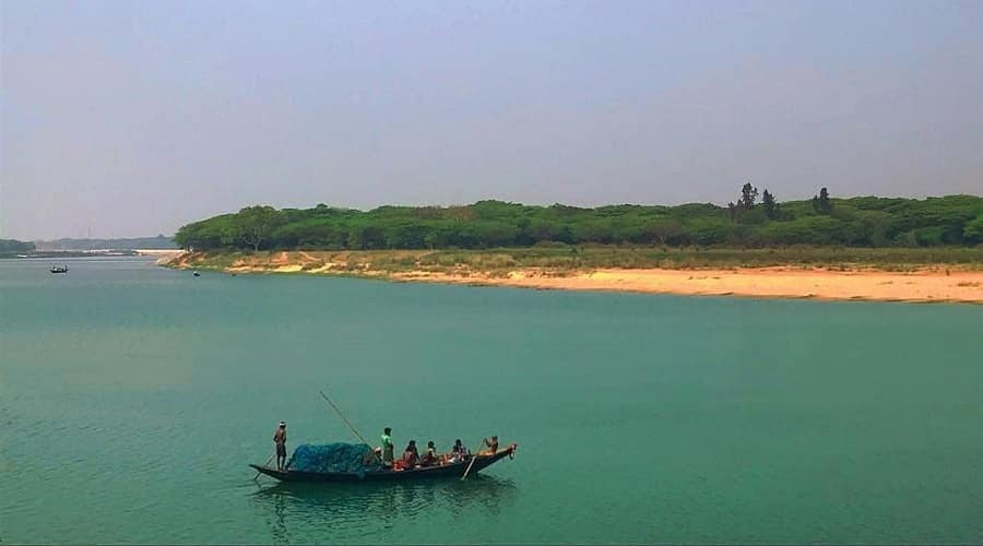
Ansupa Lake is Odisha’s largest freshwater lake, formed as a classic oxbow from an abandoned Mahanadi meander. Located ~40–46 km west of Cuttack in Banki subdivision, surrounded by the Saranda Hills. Declared a Ramsar Wetland on 12 October 2021 alongside Hirakud Reservoir.
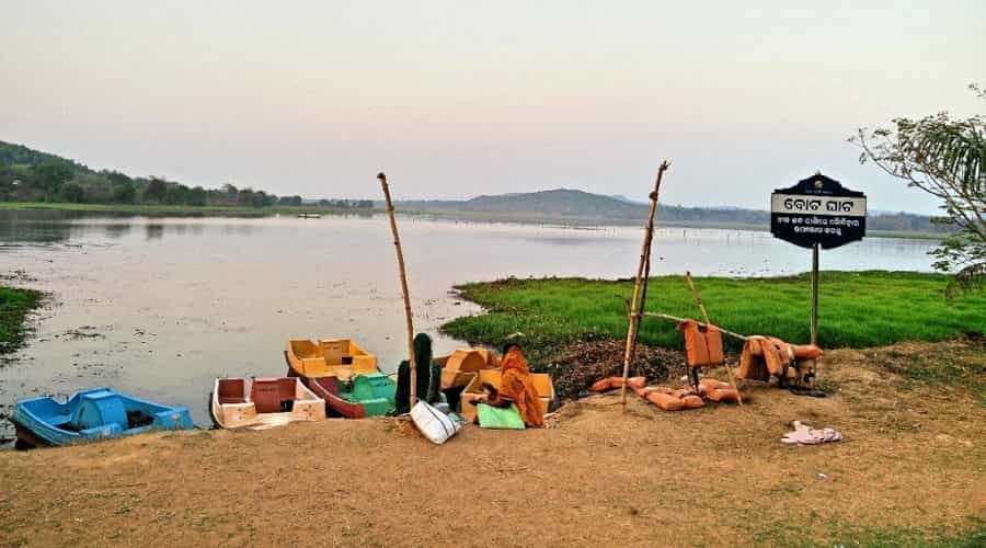
Visitor Facilities
- Ansupa Nature Camp — Odisha Tourism eco-cottages; book at odishatourism.gov.in
- Paddle boating on the lake
- Bird watching (October–February for migratory species)
- Saranda Hill viewpoint with panoramic lake views
5. Brahmani River — Odisha’s Second Longest River
| Detail | Information |
|---|---|
| Length | 799 km |
| Formation | Confluence of South Koel and Sankh rivers at Vedvyas, near Rourkela, Sundargarh |
| States | Jharkhand and Odisha |
| Drains into | Bay of Bengal at Dhamra (shared delta with Baitarani) |
| Key Districts | Sundargarh, Keonjhar, Angul, Dhenkanal, Jajpur, Kendrapara |
The Brahmani (799 km) is Odisha’s second longest river, formed by the South Koel and Sankh rivers at Vedvyas near Rourkela. It flows through some of Odisha’s most industrially and ecologically significant districts before sharing a delta with the Baitarani and draining at Dhamra.
Rengali Reservoir
On the Brahmani in Angul district, the Rengali reservoir is a scenic forested destination providing hydroelectric power and irrigation. Popular picnic spot from Angul and Sambalpur.
6. Baitarani River — Sacred River of Northern Odisha
| Detail | Information |
|---|---|
| Length | ~360 km |
| Origin | Gonasika Hills (Guptaganga), Keonjhar district, Odisha (~900 m elevation) |
| States | Primarily Odisha; small upper portion (~5%) in Jharkhand |
| Drains into | Bay of Bengal via Dhamra mouth (shared delta with Brahmani) |
| Tributaries | 65 tributaries; major: Salandi, Matai, Deo, Kanjhari, Kusei, Budhi |
| Key Districts | Keonjhar, Jajpur, Bhadrak |
| Special Feature | Originates underground at sacred Gonasika Cave; river flows through Bhitarkanika NP |
The Baitarani is one of the six major rivers of Odisha, known for its sacred origin at Gonasika Hills in Keonjhar. The river begins underground through a stream called Guptaganga before re-emerging — making the source a significant Hindu pilgrimage site. It flows 360 km through Keonjhar, Jajpur, and Bhadrak, passing through Bhitarkanika National Park’s mangrove forests before sharing a delta with the Brahmani at Dhamra mouth.
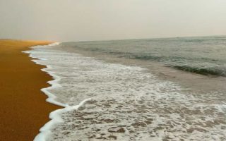
7. Rushikulya River — World’s Premier Olive Ridley Turtle Rookery
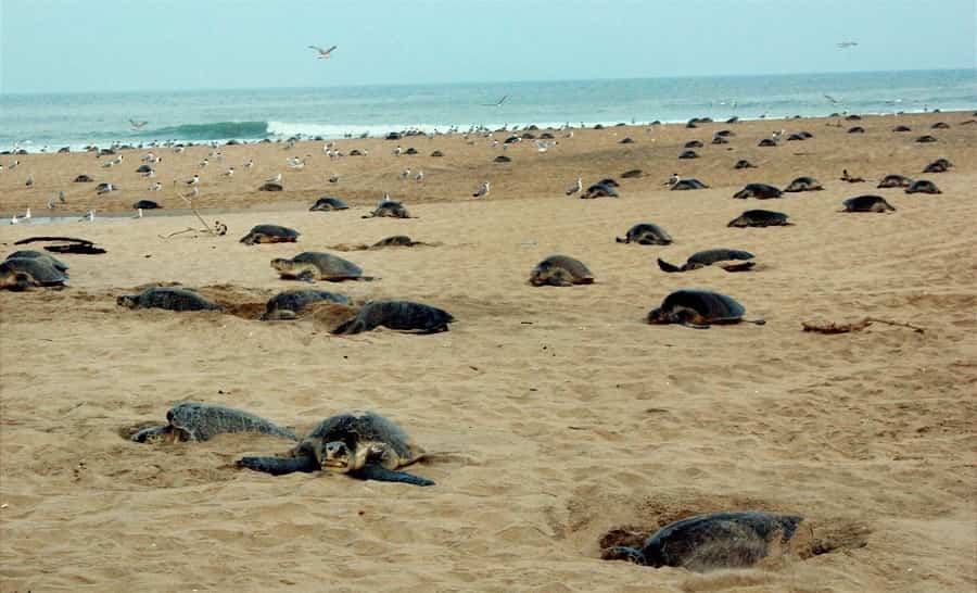
| Detail | Information |
|---|---|
| Length | 165 km |
| Origin | Rushimala Hills (Eastern Ghats), Kandhamal district (~1,000 m elevation) |
| Drains into | Bay of Bengal at Puruna Bandha, Chhatrapur, Ganjam district |
| Drainage Basin | ~7,700 sq km (entirely within Odisha) |
| 2025 Nesting Record | ~6.98 lakh (698,000) Olive Ridley turtles — highest in at least 20 years |
| 2026 Season | Nesting season started March 2026 with strong initial arrivals (10,220 turtles on Day 1) |
| Proposed Status | Odisha government initiated ‘Biodiversity Heritage Site’ tag for Rushikulya rookery (2026) |
The Rushikulya River (165 km) is entirely within Odisha, flowing from Kandhamal to the Bay of Bengal in Ganjam district. It is globally significant as one of the world’s largest Olive Ridley sea turtle mass nesting (arribada) sites. The February–March 2025 season saw approximately 6.98 lakh turtles nest at Rushikulya — a 20-year record, surpassing the previous record of 6.37 lakh set in 2023. The 2024 season saw no mass nesting at Rushikulya, making the 2025 comeback especially significant.
The 2026 nesting season has also begun strongly, with the Odisha government initiating the process to designate the Rushikulya rookery as a ‘Biodiversity Heritage Site’ covering approximately 747 hectares. Conservation efforts including ‘Operation Olivia’ by the Indian Coast Guard and strict no-trawl fishing zones have contributed to the rookery’s recovery.
8. Subarnarekha River
| Detail | Information |
|---|---|
| Length | ~395 km |
| Origin | Nagri village, Ranchi Plateau, Jharkhand (~600 m) |
| States | Jharkhand, West Bengal (83 km), Odisha (79 km) |
| Drains into | Bay of Bengal near Talsari, Balasore district, Odisha |
| Name | Subarnarekha = ‘Golden Line’ (historical gold deposits in river sands) |
The Subarnarekha (395 km) originates in Jharkhand and flows through West Bengal before entering Odisha for its final 79 km, draining into the Bay of Bengal at Talsari in Balasore district. Its name means ‘Golden Line’, referencing historical gold deposits. The river forms Odisha’s northern coastal boundary in this region.
9. Indravati River — Tributary of Godavari
| Detail | Information |
|---|---|
| Length | ~535 km |
| Origin | Eastern Ghats, Kalahandi district, Odisha |
| Primary Flow | Chhattisgarh (Bastar region) |
| Drains into | Godavari River (not Bay of Bengal directly) |
| Notable | Chitrakoot Falls (India’s widest waterfall) is in Chhattisgarh, ~40 km from Jagdalpur |
| Project | Balimela Hydroelectric Project (joint Odisha–AP project) |
The Indravati originates in Odisha’s Kalahandi district but flows mainly through Chhattisgarh before joining the Godavari. It is the lifeline of the Bastar tribal region. Chitrakoot Falls, often called India’s widest waterfall, lies on the Indravati in Chhattisgarh, not Odisha.
Other Notable Rivers of Odisha
| River | Length | Key Fact |
|---|---|---|
| Vamsadhara (Bansadhara) | ~254 km | Originates Kalahandi; drains at Kalingapatnam, Andhra Pradesh |
| Nagavali | ~256 km | Originates Kalahandi; drains Srikakulam area, AP |
| Budhabalanga | ~199 km | Originates Similipal, Mayurbhanj; drains Bay near Balasore |
| Ib River | ~250 km | Mahanadi left tributary; flows through Jharsuguda |
| Kolab River | ~250 km | Godavari tributary; forms Kolab Reservoir near Koraput |
| Tel River | ~296 km | Mahanadi right tributary; important for Koraput irrigation |
Famous Waterfalls of Odisha
| Waterfall | Location | Height |
|---|---|---|
| Barehipani Falls | Simlipal NP, Mayurbhanj | ~399 m; two-tiered; one of India’s highest; inside Simlipal Tiger Reserve |
| Joranda Falls | Simlipal NP, Mayurbhanj | ~181 m; single-drop; on Budhabalanga river system |
| Khandadhar Falls | Sundargarh | ~244 m; among Odisha’s tallest; near Rourkela |
| Duduma Falls | Malkangiri | On Machkund River; hydroelectric project site near AP border |
| Phurljharan Falls | Kalahandi | Seasonal; scenic forested setting in tribal region |
Hot Springs of Odisha
| Hot Spring | Location | Temperature |
|---|---|---|
| Atri Hot Springs | Khurda (~40 km from Bhubaneswar) | ~57°C; sulphur springs; sacred; closest to Bhubaneswar |
| Taptapani Hot Springs | Ganjam (~50 km from Berhampur) | ~65°C; forested valley; Odisha Tourism resort nearby |
| Deulajhari Hot Springs | Angul district | Sulphur springs in forest; less commercialised |
Other Notable Reservoirs of Odisha
| Reservoir | District | Key Feature |
|---|---|---|
| Rengali Reservoir | Angul | On Brahmani; scenic forested hills; picnic destination |
| Kolab Reservoir | Koraput (~15 km from town) | At ~915 m altitude; boating; joint Odisha–AP hydroelectric project |
| Balimela Reservoir | Nawarangpur (~20 km) | On Indravati; joint Odisha–AP; scenic tribal belt setting |
| Indravati Reservoir | Malkangiri (Chitrakondra) | Near Odisha–AP border; remote and scenic |
Best Time to Visit Rivers and Lakes in Odisha
| Season | Months | Best For |
|---|---|---|
| Winter | October to February | Chilika bird watching; Ansupa birds; dam visits; Olive Ridley nesting starts (Jan–Feb) |
| Spring/Pre-Summer | February to March | Rushikulya Olive Ridley nesting peak; Satkosia wildlife; hot spring visits |
| Monsoon | June to September | Barehipani/Khandadhar waterfalls at peak flow; Hirakud reservoir full; Mahanadi in flood |
| Summer | April to May | Lower crowds; Kolab Reservoir scenery; avoid Chilika — lake shrinks and heat is intense |
Odisha Rivers and Lakes — Important Facts for Competitive Exams
This section is especially useful for UPSC, OPSC, SSC, Railway, and State PCS aspirants covering Odisha GK and geography.
| Question | Answer |
|---|---|
| Largest lake in Odisha | Chilika Lake (Asia’s largest brackish lagoon) |
| Largest freshwater lake | Ansupa Lake (~231 ha; Cuttack district) |
| Longest river of Odisha | Mahanadi (858 km; largest drainage basin) |
| World’s longest earthen dam | Hirakud Dam (25.8 km) |
| India’s first Ramsar site | Chilika Lake (1 October 1981) |
| How many Ramsar sites in Odisha? | 3 — Chilika (1981), Ansupa (2021), Hirakud Reservoir (2021) |
| Hirakud Dam completed year | Completed 1953; inaugurated 13 January 1957 |
| Hexadeltaic region rivers | Subarnarekha, Budhabalanga, Baitarani, Brahmani, Mahanadi, Rushikulya |
| Odisha’s highest waterfall | Barehipani Falls (~399 m), Simlipal NP, Mayurbhanj |
| Olive Ridley turtle nesting sites | Gahirmatha (Kendrapara), Rushikulya (Ganjam), Devi River mouth (Puri) |
| Mahanadi states | Chhattisgarh and Odisha only (NOT Jharkhand or MP) |
| Baitarani origin | Gonasika Hills, Keonjhar district, Odisha |
| Which river flows through Bhitarkanika? | Baitarani (lower reaches) and Brahmani |
Explore More About Odisha’s Natural Attractions
- Chilika Lake Travel Guide — Satapada dolphins, bird watching, Kalijai Temple, boat tours
- Hirakud Dam Sambalpur — Visitor guide, Cattle Island, Debrigarh Wildlife Sanctuary
- Bhitarkanika National Park — Mangroves, crocodiles, Baitarani lower reaches
- Simlipal National Park — Barehipani Falls, tigers, Mayurbhanj
- Rushikulya Beach Olive Ridley Turtles — Nesting season guide
- Satkosia Gorge Ecotourism — Mahanadi canyon, tiger reserve, river camps
Must Reads on: Most Popular Beaches of Orissa
FAQs
Q1. Which is the largest lake in Odisha?
Chilika Lake is Odisha’s largest lake and Asia’s largest brackish water lagoon, covering 900–1,165 sq km. Ansupa Lake is Odisha’s largest freshwater lake at approximately 231 hectares.
Q2. Which is the longest river in Odisha?
Mahanadi is Odisha’s longest river at 858 km total (494 km within Odisha). It has the largest drainage basin in the state at ~141,600 sq km and is the sixth largest river in India by water potential.
Q3. Is Chilika Lake a Ramsar site?
Yes. Chilika Lake was designated India’s first Ramsar Wetland on 1 October 1981. It was on the Ramsar Montreux Record (Threatened) from 1993 to 2002, then removed after restoration — the first Ramsar site in Asia to achieve this.
Q4. When was Hirakud Dam completed and inaugurated?
Hirakud Dam was completed in 1953 and formally inaugurated by PM Jawaharlal Nehru on 13 January 1957. The foundation stone was laid on 15 March 1946, and first concrete was poured on 12 April 1948.
Q5. How far is Ansupa Lake from Cuttack?
Ansupa Lake is approximately 40–46 km west of Cuttack city in the Banki subdivision of Cuttack district. The nearest railway station is Raja-Athagarh (~20 km from the lake).
Q6. How many rivers flow through Odisha?
Odisha has 11 major rivers. The main ones are Mahanadi, Brahmani, Baitarani, Rushikulya, Subarnarekha, Budhabalanga, Vamsadhara, and Nagavali. Mahanadi and Brahmani are the two longest rivers flowing through Odisha.
Q7. What is Hirakud Dam famous for?
Hirakud Dam is the world’s longest earthen dam at 25.8 km, built across the Mahanadi near Sambalpur. Its 55 km reservoir was declared a Ramsar site in 2021. Power generation started in 1956 with an installed capacity of 347.5 MW.
Q8. How many Ramsar sites are in Odisha?
Odisha has three Ramsar sites: Chilika Lake (designated 1 October 1981 — India’s first), Ansupa Lake (12 October 2021), and Hirakud Reservoir (12 October 2021). Both Ansupa and Hirakud were designated on the same date.
Q9. Which river forms the largest delta in Odisha?
Mahanadi forms the largest delta in Odisha, a broad fertile delta near Paradip and False Point on the Bay of Bengal coast. The Brahmani and Baitarani together form a shared delta known as the Dhamra estuary.
Q10. Which is the deepest lake in Odisha?
Chilika Lake is the most significant deep-water lake in Odisha, with depths varying across its sub-sectors. The outer channel area connecting to the Bay of Bengal is the deepest zone. Ansupa Lake is relatively shallow as an oxbow lake.
Q11. What is special about the Baitarani River?
Baitarani originates at the sacred Gonasika Hills in Keonjhar, where the river initially flows underground as ‘Guptaganga’ before re-emerging. This source is a major Hindu pilgrimage site. The river flows through Bhitarkanika National Park’s mangroves in its lower course.
Q12. Where do Olive Ridley turtles nest in Odisha?
Odisha has three major Olive Ridley nesting sites: Gahirmatha Marine Sanctuary (Kendrapara), Rushikulya river mouth (Ganjam), and Devi River mouth (Puri). Rushikulya saw a record ~6.98 lakh turtles in February 2025. The 2026 nesting season has also begun strongly.
Q13. What is the Hexadeltaic region of Odisha?
Odisha’s coastal plain is called the Hexadeltaic region — the ‘gift of six rivers’. The six rivers forming it are Subarnarekha, Budhabalanga, Baitarani, Brahmani, Mahanadi, and Rushikulya. These rivers divide the coastal plain into three zones from north to south.
Q14. Which is Odisha’s most famous waterfall?
Barehipani Falls in Simlipal National Park, Mayurbhanj, is Odisha’s most famous waterfall at approximately 399 m — one of India’s highest. Joranda Falls (~181 m), also in Simlipal, and Khandadhar Falls (~244 m) in Sundargarh are other major ones.
Q15. What are the most famous lakes in Odisha?
The most famous lakes in Odisha are Chilika Lake (Asia’s largest brackish lagoon; Ramsar 1981), Ansupa Lake (Odisha’s largest freshwater lake; Ramsar 2021), and Hirakud Reservoir (world’s longest earthen dam reservoir; Ramsar 2021). Kanjia Lake near Bhubaneswar is also a notable bird habitat.
Q16. Is Rushikulya beach safe for tourists during nesting season?
Rushikulya beach is accessible to tourists outside the nesting period (typically February–March), but during mass nesting, beach access is regulated by the forest department to protect turtles. Guided eco-tours to view nesting from a distance are organised by the Odisha Forest Department.
Q17. What are the rivers flowing through Bhitarkanika National Park?
Bhitarkanika National Park in Kendrapara district is traversed by the Brahmani River and its distributaries, as well as the lower course of the Baitarani. These rivers support the largest mangrove forest ecosystem in eastern India and are home to saltwater crocodiles.
Q18. Which river in Odisha has the sacred underground source?
The Baitarani River originates at Gonasika Hills in Keonjhar, where it first flows underground as ‘Guptaganga’ before emerging from a cow’s-nose-shaped rock formation. The site is a major pilgrimage destination and the river is mentioned in ancient Hindu texts.
Conclusion
The rivers and lakes in Odisha represent one of the richest water-body ecosystems in peninsular India. Chilika Lake — with its 159 Irrawaddy dolphins (Feb 2026 census), over 225 bird species, and Ramsar designation since 1981 — remains Asia’s most extraordinary coastal lagoon. The Mahanadi’s 858 km journey powers the world’s longest earthen dam. Rushikulya’s river mouth hosts Olive Ridley turtle mass nesting of global significance, with nearly 7 lakh turtles in 2025. The drainage system of Odisha — all 11 major rivers and three Ramsar wetlands — forms an ecological network that is irreplaceable.
For travellers, October to February is the best time to visit Odisha’s water bodies. For Rushikulya turtle nesting, February to March is the window. For waterfall photography at Barehipani and Khandadhar, monsoon (June–September) is the time. These water resources of Odisha reward every kind of visitor — pilgrim, wildlife watcher, ecotourist, or competitive exam aspirant.
- Also Read on: Best Things to Do in Odisha